Thursday, March 29, 2007

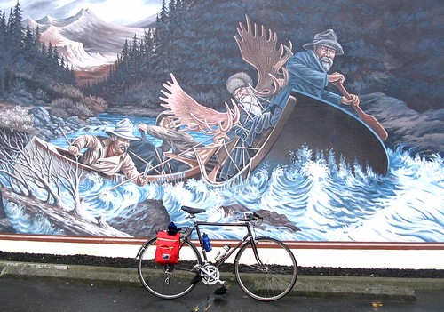
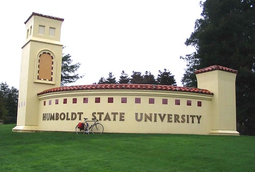
Lord Ellis/Berry summits

Earlier this week CP asked me where I planned to ride.

My answer: Somewhere far away.

I didn’t know where I would be pedalling, but I wanted to log a lot of miles, do some serious traveling and come home really tired. You know – no pain, no gain.

I checked the weather forecast Wednesday and determined that Thursday would be perfect for a ride east on State Highway 299. I would climb some mountains and perhaps even make it as far as Willow Creek.

As usual, I awoke later than planned. I ate two fried eggs, a piece of toast, loaded up the bike and got ready to leave. Then I decided to take a shower.

What? Who the heck showers before a long bike ride? That doesn’t make any sense.

The thing is, taking a shower is part of my morning ritual. If I don’t follow that routine, I feel out of whack. So it’s dumb, and a sure sign of a serious mental flaw, but it had to be done.

Arcata Bottoms looking east

After a short shower, I filled a canteen with some piping hot Earl Gray tea and by 8:30 a.m. I was rolling across the Arcata Bottoms, above. I would conquer those mountains in the distance.

Next Service sign

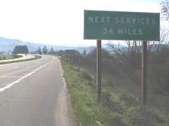
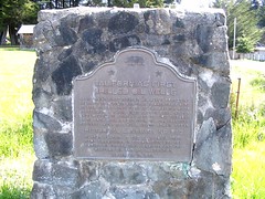
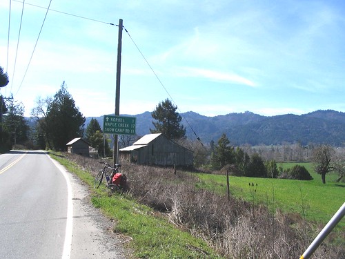
I made my way to Valley West and proceeded up 299 to Blue Lake, where I came across this sign. There’s no food and no water. You’re on your own out here, which I planned for.

Besides the small canteen with the tea, I had three large canteens with water, one V-8 Splash, a tuna sandwich, assorted dry fruit, a slice of Morning Bread from Sutter’s Mudd and a Snicker’s Bar.

A short distance up the hill from Blue Lake I stripped down to a bicycle jersey and shorts. I was sweating like a pig. Good thing I took a shower before I left.

Lord Ellis

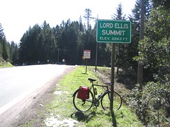
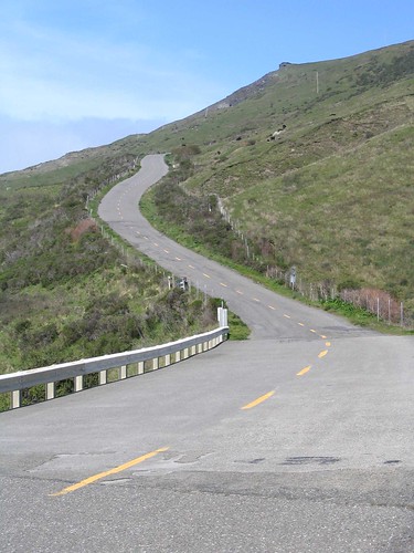
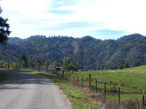
I came across lots of snow and made it to the top of Lord Ellis Summit, elev. 2,263, above. Then I descended down the other side to Redwood Creek. It was a long, chilly descent.

I felt like I was cycling in the Alps. I was surrounded by mountains dotted with snow. When I got to the bottom I began climbing the next mountain.

Looking west

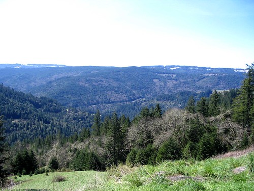
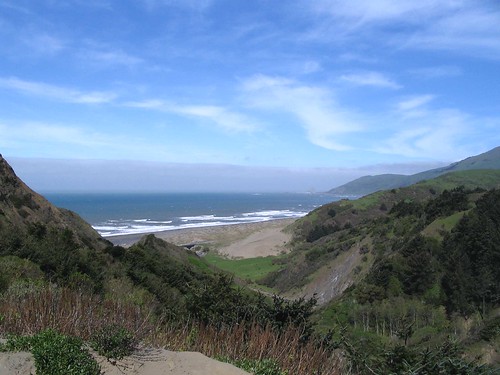
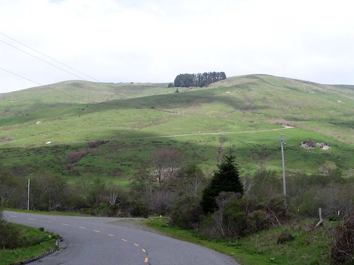
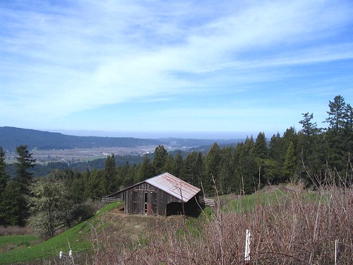
Above is the view looking southwest on the way up to Berry Summit. I came up and over that mountain in the distance, descended into the valley below and climbed up to where this photo was taken.

Snow at Vista Point

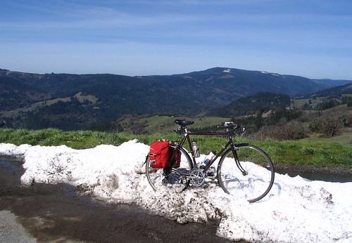
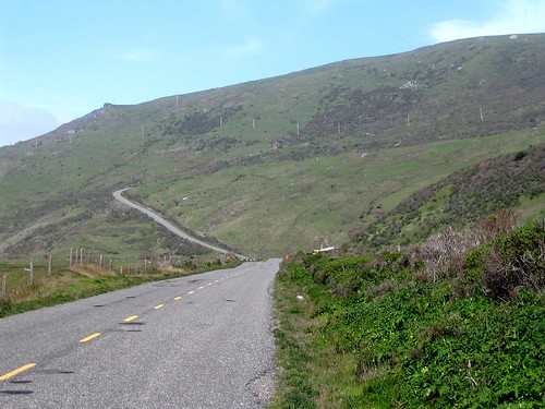
As I got closer to the summit, there was a strong easterly wind. I stopped at the Vista Point, above, and consumed some fuel. I didn’t see a sign indicating I had reached the actual summit, which is 2,859 feet, according to my map. But I was close.

At this point I was about 8 or 9 miles from Willow Creek. I thought about going all the way, but that would involve an extra 16 of 18 miles of cycling along with more than 2,000 feet of additional elevation gain on the way back.

Could my legs handle it? I wasn’t sure. So I turned around and came back. I climbed back to the top of Lord Ellis Summit and coasted down to Blue Lake. I decided to take Fieldbrook Road home and got back into town around 3:30 p.m. I had enough time to stop at the office, make a few phone calls, and then swing on by Soulshine for a juicy tofu burger smothered in jalapenos.

When I got home I realized that, although tired, I felt pretty good. There were several hours of sunshine left in the day. Next time I’ll go all the way to Willow Creek.

Saturday, March 24, 2007

Recommended reading

Jennifer's Ride From Ferndale

Good stuff.

Friday, March 23, 2007

Petrolia and "The Wall"

I did more driving than pedalling Thursday when I went to Petrolia to check out a section of the Tour of the Unknown Coast route.

monument

I parked my car near this historical landmark, which explains how Petrolia got its name. “California’s First Drilled Oil Wells” were located not far from here, with the first shipment sent to San Francisco in 1865.

The ride west of Petrolia is very pleasant, with lots of green hills and tidy little ranches. It was warm and sunny.

Petrolia at ocean

This is the view before descending to the beach. There was a strong headwind, which made for a slow ride along the coast.

Graffiti before The Wall

I came across this ominous graffiti right before hitting “The Wall,” a brutally steep climb that’s often noted in reports about the Tour of the Unknown Coast. Just in case I decided to keep my cussing to a minimum when the climb began.

The Wall from afar

Gulp! Here’s a photo of “The Wall” from a distance. It reminds me of the south end of Union Street in Arcata, except it keeps going up and up.

The wall

And here’s a closer view.

I used my granny gear and slowly climbed it. The bike moved so slow it’s a miracle I didn’t fall over. I probably could have made better time just walking it, but I wanted to see if it could be done.

When I got near the top a rancher drove by and rolled down his window. “Right on! If you can do that, you can do anything. Yeah!” he cheered.


Beyond The Wall

I went up and over the mountain and down the other side. After you conquer “The Wall” you’re treated to another steep climb, above. It was getting late so I turned around and made my way back to Petrolia.

It was a short training ride – about 28 miles total. Since I had driven to Petrolia from the Weott side, I decided to return home by driving from Petrolia to Ferndale – the same route as the TUC.

It looks like about 10 miles of serious hill climbing between “The Wall” and Ferndale.

Wednesday, March 21, 2007

Confession: I carry a hot pink lady’s purse...

Actually, I carry two purses, one inside the other – a sassy hot pink purse and an elegant little brown bag.

Both are quite lovely, but you won’t find me sashaying around town with them. These purses are tucked away in my panniers, backpack or bicycle bag, depending on which bicycle in the fleet I decide to use on any given day.

I got tired of packing my tools around wrapped in a greasy rag inside a plastic Safeway bag, so I asked CP if she had any extra purses. She opened a drawer and about a million of these bags fell out. They look like purses to me, although technically they might be makeup bags.

Purses with tools

The bag on the right carries the patch kit and the CO2 tire inflator. The bag on the left carries everything else, including the smaller purse.

Everything is packed nice and tight. There’s a strong zipper and the material is water resistant.

Best of all these “tool bags” were free.

That means something, especially after spending $40 today on a new rear wheel. The rear axle was bent on my old wheel and fixing it didn’t make a lot of sense given the cost involved and all the internal damage that was probably caused riding on it.

Friday, March 16, 2007

Butler Valley/Maple Creek

Sometimes inspiration comes from the strangest places, like this week when a guy called me a “fucking pussy” and threatened to kick my ass.

It happened on U.S. Highway 101 near School Road late Wednesday afternoon. Some idiot had veered off the freeway and flipped his Mustang over in a drainage ditch. I arrived on scene – shortly after the CHP – to take photos for the newspaper.

The driver of the vehicle asked me who I was, so I identified myself. He then threatened to “press charges” if the photos were printed. That was such a dumb statement I wasn’t sure how to respond. I held my tongue and politely explained how things work. Apparently he didn’t like what I had to say. He had a little fit and walked away.

After I got my photos and interviewed a CHP officer, I started to leave, but not before being confronted again by the driver.

He told me that I was making him mad and that he wanted to punch me and kick my ass. My first thought was that I should probably just leave. That would be the smart thing to do.

But before I could do so, he gave me an ultimatum – leave NOW or the punching would begin.

Damn. Them’s fightin words!

I pointed out to him that there were two CHP officers standing nearby and that it would be interesting to see what would happen if he started punching me.

He replied “Fuck you!”

I said “Why don’t you go for it and see what happens.”

Then he declared that I was a “fucking pussy” and reiterated his threat to punch me.

There were no punches forthcoming. He didn’t even step forward in preparation to fight.

At this point I was relieved because he appeared to be all talk.

I then suggested that we immediately walk over to the CHP officers and discuss this issue. They might be interested to know that he was threatening me with bodily harm.

“Let’s talk to them right now,” I said. I gestured in their direction and took a step forward.

Suddenly a surprising thing happened. The guy looked away, took a couple steps back and lowered his head. He crossed his arms over his chest and looked deflated.

I told him that I would do him a “favor” and not tell the CHP about his threats. He was silent. At that point he probably just needed a big hug and a shoulder to cry on. I would have felt bad for the guy if he wasn't such an asshole.

I walked away happy as a clam. His car was dragged out of the ditch. The cause of the accident: DWS (Driving While Stupid). He couldn't even blame this one on booze.

The next day I woke up for a real ass kicking – the Butler Valley/Maple Creek ride. I had first heard about this route from my friend Casey, who knew a guy who incorporated it into his bicycle commute from Eureka to Arcata. (The guy must have a few screws loose.) Then, over the weekend, I read that the Bigfoot Bicycle Club was planning a Butler Valley social ride last Sunday. I couldn’t make Sunday’s ride, so I decided to do it Thursday. Club member Tim Daniels was kind enough to e-mail me the particulars.

I loaded the bike with a ham & cheese sandwich, chips, Baby Ruth, a slice of cranberry bread, a canteen of coffee and lots of water. I was pedaling out of town by 10 a.m.

Murray Road

I went up Murray Road, above, and over the hill to Fieldbrook. I got concerned at that point because my legs were still sore from the day before, when I pedalled 18 “commuter” miles.

From Fieldbrook I pedalled to Blue Lake, then Korbel.

West of Korbel

The photo above is just west of Korbel. I would have to climb those mountains in the distance.

Indian Arrow Tree

On Maple Creek Road I came across the Indian Arrow Tree. I have no additional information about this event other than what's in this photo of a wooden plaque nailed to the tree.

View from Maple Creek Road

Here’s the view from Maple Creek Road. It’s spectacular. You’re pretty much alone out there except for the cougars and sasquatches. That valley below is the Blue Lake area.

East of Kneeland

My legs were sore. Really sore. I thought about my legs when I looked at the mountains above. This is the backside of Kneeland and I would need to climb up and over them.

The Neanderthal’s words from Wednesday rang in my head: “You’re a fucking pussy!” Well, I guess I was about to find out if that was true. Maybe he was right.

It was a grueling ride to the top. Everything hurt – my hands, my arms, my legs, my knees, my ass. When I got into a bad funk or felt like stopping, I just told myself “don’t be a fucking pussy.”

Up and up it went. It took a lot longer to get to Kneeland than I thought it would. Finally, somewhere above the Kneeland Post Office, I hit the top. I coasted downhill and was relieved when I reached Old Arcata Road.

I slogged my way home mile by mile. I felt like a hundred-year-old man.

After my ride I checked my mileage on google. I thought for sure it would come in at 75 to 80 miles, but it was 57 miles. I suppose the 3,400 (unconfirmed) feet of elevation gain is what made it so difficult.

Although difficult, this was one of the best rides I’ve been on. I was completely unfamiliar with everything between Korbel and Kneeland, so it was a real adventure.

Friday, March 09, 2007

Almost to Orick... almost

Mileage so far in 2007: 621

***

Sometimes when I’m on a long ride my thoughts turn to work.

I think about all the things I should have done before the ride, the things I should be doing instead of riding, and the things I need to do after the ride.

I need to make an ad for a local beauty parlor and get it proofed. Jody wants to talk about an article idea. Someone wants to know how to subscribe. Billing. Renewals. Page layout. Briefs. Articles. Subscriptions.

The list grows longer and longer and I begin to wonder what the hell I’m doing pedaling a bicycle to Freshwater Lagoon and back in the rain on a Friday morning when I should be attending to business. I work myself up into a lather. I should stop. Call a cab. Hurry home. Get back to work.

Then I come to my senses. Work can wait. Besides, whether I ride or not, I’m still going to put in 60 hours or more for the business this week. Ain’t that enough?

Besides, I’m on a mission.

The panic subsides and my focus returns. I maintain a steady pace and change gears frequently. I scan the road ahead for broken glass and rusty nails. I dodge an empty vodka bottle. I startle a red-tailed hawk.

It sprinkles. It rains. Then it stops raining. I take off my raincoat. Then it starts raining again. Raincoat back on. Multiple costume changes again and again. Gloves on. Gloves off.

Glasses are fogged over and covered in raindrops. I try to wipe them but it’s pointless. The rain keeps falling. Sometimes I view the road through a foggy kaleidoscope.

I have no pretensions about keeping the body dry – I just want to maintain some sort of relatively dry portion of the upper torso. Unless I’m mistaken it’s what bicycle guru Kent Peterson calls “comfortably damp.”

I get as far as Freshwater Lagoon and decide to take a 10-minute break inside the sheltered picnic area on the north side of the spit. I nibble on a stale PB&J sandwich and force myself to consume water. Not the tastiest meal, but it will be adequate fuel if I can get it down.

Break over. Time to turn around. Wind gusts hammer me as a make my way back home. The raindrops feel like a shotgun blast to the face. I lean into it. A wicked smile overcomes me. I shouldn’t be smiling. I should be frowning. But I’m loving it. I’m cold and there’s a burning sensation in my legs, but I feel pretty good. Damn good.

I feel a heck of a lot better than I did a couple weeks ago when I rode this far. I’m not sure if my training regime is adequate for the Tour of the Unknown Coast, but it seems to be working in the sense that this week’s ride is easier than it was before.

I left the house this morning at 7:52 a.m. and checked the watch on a regular basis throughout the morning. I thought about work more and more and, sometime near Stone Lagoon, I came to my senses. I vowed not to check the watch again until I returned home.

On the way home, I pedaled faster. I stood up and cranked the bike up the hills. I hummed along at a nice pace.

Big Lagoon. Highway 101. Patrick’s Point State Park. Larrupin Cafe. Trinidad Inn.

City of Trinidad. Scenic Drive. Casino. Luffenholtz. Moonstone. Little River. Clam Beach. Airport. Hammond Trail. School Road.

Home.

Time: 1:28 p.m.

Now it’s time for work.

Friday, March 02, 2007

Ride.Eureka.3.2.07

Date: 3.2.07

Goal: Complete some sort of training ride despite inclement weather.

Planned wake up time: 7 a.m.

Actual wake up time: 8 a.m.

Distractions before departure: E-mail, SFgate.com, breakfast, Fred’s blog, Eric Kirk’s blog, Steve D.’s blog (not local, but always entertaining), washing dishes, making pesto pasta for ride, packing lunch.

Pre-Ride Thoughts: Cold and wet outside. Want to stay home. Should skip ride and work. Lots of calls and unreturned e-mails to be addressed.

Inspiration for leaving house: Hot coffee from Sutter’s Mudd. Blueberry muffin that can’t be consumed until first rest stop.

Departure time: 9 a.m.

Destination: Downtown McKinleyville for coffee. Arcata Bottoms, Woodley Island. And...????

Weather: Crappy, with rain and drizzle.

Clothing: Outer shell – rain jacket, rain pants, gloves. Inner shell – sweat pants, T-shirt, shorts, etc.

Mad River (Looking east from Hammond Bridge)

First photo: Mad River looking east atop Hammond Bridge. Actual photo too dark and gray. Radical color adjustment necessary.

First rest stop: Woodley Island. Consumed muffin. Finished coffee.

Most depressing area: Old Town Eureka. Homeless coughing up lungs. Staggering about. Empty corners. Did street hookers take the day off?

Improvised riding technique: Utilized sidewalks along portion of Broadway.

Bucksport mural

Costume change: Stopped at Bucksport to remove rain gear after it finally stopped raining.

Costume Change II: Three minutes later the rain resumed. Jacket back on.

Major route change: Took Herrick Ave. exit. Weaved my way past golf course to Redwood Acres and Myrtle Ave.

Heavy rain: Went from wet to wetter along Myrtle Ave./Old Arcata Road.

HSU

Homeward bound: Old Arcata Road. Union Street. L.K. Wood Blvd. Janes Road. Arcata Bottoms. Hammond Bridge.

Arrive home: 1:30 p.m.

Miles: 39

Notes: Weather sucked, but I felt good. Lots of extra energy at end of ride. Need improved weather and longer distances.

Free Website Counter
Hit Counters