Birth of an idea
Why, you may ask, is this photo posted on my blog?
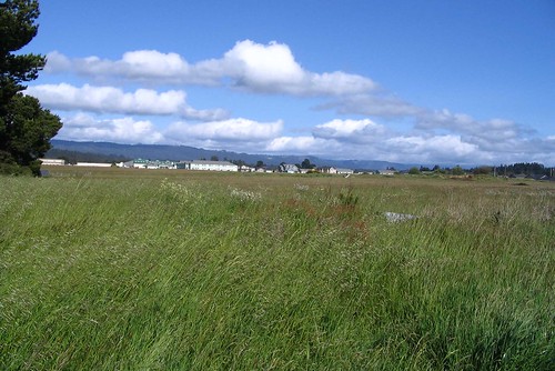
It’s not a work of art, nor is it visually interesting. It’s a mere snapshot of a field in McKinleyville. Rather dull, one might say.
But it represents the birth of an idea, one that I’m still pondering – a website documenting McKinleyville’s landscape. I thought about it when I stopped at this location this afternoon on the way home from work.
Maybe it would be a new blog, or just a “flickr” page where a couple photos a week could be uploaded at my leisure.
The idea would be to document the landscape as it is today. I would focus on Central Avenue and other areas of town that one can reasonably expect to be transformed in the near future.
I might slowly work my way from one end of Central Avenue to the other, taking photos of everything from Kmart to Sutters Mudd to Opie’s to the McKinleyville Shopping Center.
Nothing fancy, mind you, just clear photos showing what everything looks like today.
There would be a certain delayed gratification with the project because it would take some time before the photos would be appreciated.
Take, for example, the photo above. Boring stuff, eh? A waste of pixels.
But within the next couple years Heartwood Drive will slice right through the middle of that field. Then houses and apartments will start popping up. Pretty soon the entire field will be an asphalt jungle. It might take three years, or four years. Maybe five.
When the landscape is altered, this photo will be a historical gem. People will look at it and say “I remember when...”
The same would be true for photos taken on Central Avenue, or anywhere else in town.
This is something I wish I would have done when I moved here about 14 years ago. Remember Maggie's Burgers? Moon's Barbershop? The ranch that is now the Mill Creek Marketplace? The McKinleyville Senior Center when it was located behind the A-frame? How about when the Sheriff's office was located right next to the donut shop?
They would be kind of like the photos sent out by the Humboldt County Historical Society with its press releases – photos of downtown buildings at the turn of the century, old homes, lumber mills, farms.
I find those photos interesting, but when they were taken they were no different than the photo I posted above.
This is a simple idea, and one that could be done at my leisure a couple photos at a time.
After I get a few more things done, like putting out a paper and then riding in the TUC next week, I’ll put some thought into this.
posted by Jack Durham at 5:41 PM
![]()

8 Comments:
I think that's a spiffy, idea, Jack, and you're absolutely spot-on about today's hum-drum snapshot magically becoming a treasure in 100, 50 or even 20 years from now.
I recently found a c1900 photo of what's now A&L Feed, and went out with my cheapo digital camera and recreated the view. The feed store, and the apartment (?) to its north are little changed, but everything else in sight is dramatically different. Even the railroad tracks that crossed Central there are now replaced by the crosswalk leading to the Middle School.
Who would have known then... and who would know now?
Agreed. Neat idea. I was thinking of the same sort of thing. Not so much doing it, but wishing someone else had done the same thing over the last few decades or even the last century up here.
I was envisioning a sort of Google Earth type map of, say, Eureka (maybe the whole county?). Get every known picture of every location in Eureka. Then, present them as a year by year progression. You could either look at the city grow, overall, or zoom in and see how a certain location developed.
Like my house for instance. My house was started in 1880. The Matteoli's house, across the street, in 1925. It would be interesting to see a progressive photo exhibit of how the neighborhood was developed. I'd be especially interested in what the area around my house looked like in, say, 1885, when most houses around mine weren't here.
Of course, I don't know when aerial photos started being used regularly, suffice it to say, we probably don't have access to such resources in the early 20th century or earlier. Still, there's other maps, drawings and photos available where one could construct a progressive montage of sorts.
It would be a herculean task, indeed, and I certainly don't have the knowledge or energy to partake in such and endeavor. Like I said, I just wish someone else would do it, or HAD done it.
But your project, while it would be entertaining to Humboldt residents now, might be really something for people five, ten, twenty years from now and beyond.
Too bad someone couldn't of started a similar project up here 150 years ago.
I was looking at my "Flickr" photo page and discovered that you can upload a photo and then place its location on a map.
So you could open the map, click on an intersection and selected the photos that have been uploaded for each corner.
Each photo then pops up with a brief description.
Pretty simple. It might make sense to start with the major intersections.
The next step would be to have maps in chronological order. Even better would be just one map, perhaps more of a picture or Google earth type photo, that could morph from year to year as you watch it.
Set the map to run from, say, 1920 to present. The and watch an area transform itself through the years. All the time, of course, you could zoom in for more detail on specific locations.
As I said, it would be a herculean task. Just gathering and indexing all the photos would be problematic by itself.
Would probably make a fun project for combined organizations like say, the Historical Society and some college computer or graphic arts class, plus any other interested volunteers.
Jack,
I have a McK aerial photo from 1938 or 1940. You can see A & L, old highway 101, and Railroad Drive. Also have a picture of Grandfather Julius in front of an airplane at Dow's Prairie (with a recently clear-cut hillside behind him). Do you think they had any idea these photos would be discussed on blogs 50 years later? Good project.
Great idea! And have a great TUC. What an experience... can't wait to hear about it in your blog.
Great idea, Jack. It's not silly to take a photo of the field, someday no one will be able to imagine it was once open space. Check out the old photos in Burger King, It's amazing really.
I was thinking, Jack - aside from the fact that you may want to take all your own photos - you should do a "day in the life" project in conjunction with the high school, maybe the photography class at Mck High, maybe broader - have students fan out and take shots all over town. Be quite an interesting view into today's life. Add that to all of your photos, and all the old historical photos you are sure to be offered, and you will have quite a record.
Post a Comment
<< Home