Changes at the Mad River mouth
These aren't pretty photos, but they show what's happening at the Mad River mouth.
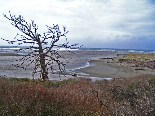
This was taken Friday, Jan. 4. Use the old tree as a reference point and take notice of the north and south sides of the mouth. The river was flowing strong that day and was filled with logs and debris.
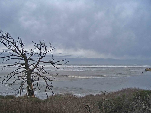
This is the north side of the mouth today, Jan. 9.
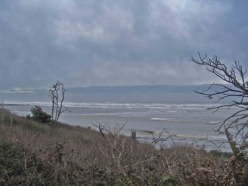
Here's the south side. Around 1 p.m. Thursday there will be a high tide. Add all the rain we've had, along with high surf, and things could get interesting.
posted by Jack Durham at 1:47 PM
![]()

5 Comments:
Jack, it would be appropriate to disclose the tidal heights in your pictures. Also, the pan view is different because zoom-in / zoom-out focus/range setting is different. Effectually, bearing points in some pictures were hidden out of others.
Jeffrey Lytle
McKinleyville - 5th district
My tide chart shows that there was a high tide of about 7.37 at 11:27 a.m. The photos were taken at about 1:10 p.m.
Thank You Jack.
I was wondering if you could give the tidal height and time for your picture dated on January 4, 2008.
I am uncertain of your data on the tidal heights and times.
Jeffrey Lytle
McKinleyville - 5th District
I have no idea and I'm too lazy to look it up. However, I'm sure you could find it on the internet.
Or, you could take a simple approach – the Jan. 4 photo was obviously taken during a relatively low tide. The recent photos were taken during a relatively high tide. The recent photos have the same focal length. The Jan. 4 photo has the same, or similar, focal length.
The reason the photos were taken when they were taken had to do with where I was on that particular day.
I don't use this information for navigational purposes, even though I have a small schooner filled with grizzly pelts and moonshine currently docked near the Hammond Bridge. I need to sail it to Trinidad, but before I do so I'm going to get some accurate GPS readings and wait for a really high tide and a southerly wind. Then I'll sail north and trade my goods for some gold nuggets, elk jerky and wild blackberry preserves.
I considered using Dennis Mayo's ponies, but I'm not sure they'd make it across the Little River.
LOL!
Post a Comment
<< Home